Kilikia Tracheia, Rough Kilikia, a land of hills, valleys, steep slopes, and narrow tracks, a land of villages, small towns, and many ports, which had been rarely under any government’s control.
Cilicia was the ancient name of the southeastern part of Asia Minor, which is now part of Turkey. It was bordered to the south by the Mediterranean Sea, to the west by the Western Taurus Mountains (Batı Toroslar in Turkish), to the north and northeast by the Central Taurus Mountains (Orta Toroslar in Turkish), and to the southeast by the Amanus Mountains (Nur Dağları in Turkish). It is worth mentioning that the boundaries of the later Roman province of the same name changed several times and that further significant changes in territorial administration occurred during the Byzantine period.
The term Cilicia is the Latinized form of Greek Kilikia (Κιλικία). The area has been inhabited since the Neolithic period, and the Greek name Kilikia derives from the earlier Assyrian name Hilakku.2 The name is first attested in Greek literature in Homer’s Iliad, where the Cilicians are mentioned.3 Herodotus and some later ancient writers state that the land was named after the mythical founder Cilix (Greek Κίλιξ / Kilix), son of the Phoenician king Agenor and brother of the mythical Europa.4
In ancient times, Cilicia was divided into two parts. The western part was called Cilicia Trachea (Greek Κιλικία Τραχεῖα / Kilikia Tracheia, i.e. ‘Rough’ or ‘Rugged Cilicia’) and the eastern part Cilicia Pedias (Greek Κιλικία Πεδιάς / Kilikia Pedias, i.e. ‘Plain’ or ‘Flat Cilicia’).5 The interior of Cilicia Pedias consisted of a large fertile coastal plain watered by the rivers Cydnus (Greek Κύδνος / Kydnos, now the Berdan or Tarsus River), Sarus (Greek Σάρος / Saros, now the Seyhan River) and Pyramus (Greek Πύραμος / Pyramos, now the Ceyhan River).
Cilicia Trachea, on the other hand, was predominantly mountainous. It extended from Cape Anemurium in the west (near the present-day town of Anamur)6 to the Lamus River in the east (Greek Λάμος / Lamos, now the Limonlu River or Limonlu Çayı in Turkish), which separated it from Cilicia Pedias. This area is formed by the spurs of the Taurus Mountains, which often terminate in rocky headlands with small sheltered harbours. The region is traversed by small rivers and dotted with small valleys and basins that supported village-sized communities. In the interior, a number of peaks exceed an altitude of two thousand metres. Fertile land is scarce and found mainly in some coastal areas and in the Calycadnus River valley (Greek Καλύκαδνος / Kalykadnos, today the Göksu River or Göksu Nehri in Turkish).
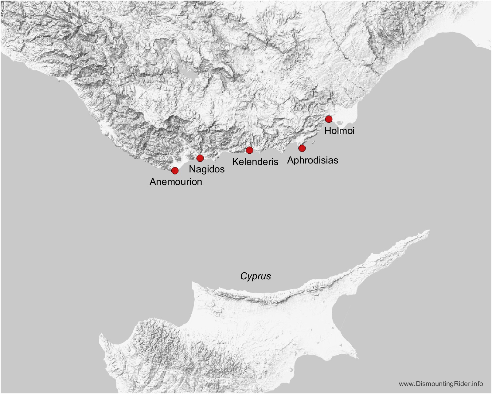
Greek colonisation of Cilicia Trachea probably began in the 8th century BC.7 Given the geographical conditions, it is not surprising that Greek cities (πόλεις / poleis) were founded on the coast. Five Greek poleis are known in the pre-Hellenistic period. From west to east, these were Anemourion (Ανεμούριον), Nagidos (Νάγιδος), Kelenderis (Κελένδερις), Aphrodisias (Ἀφροδισιάς) and Holmoi (Ὅλμοι).8 For some of them, a connection with an earlier settlement may be assumed. Despite the scarcity of fertile land, there were probably several reasons for the colonisation of this area. An important attraction may have been the forests of the Taurus Mountains, which consisted mainly of cedar and pine and provided timber for shipbuilding. Other important factors are likely to have been favourable conditions for the construction of ports and the strategic location close to the maritime routes connecting the Levant and Cyprus with the Aegean and other parts of the Greek world.
In the second half of the 6th century BC, Cilicia became part of the Persian Achaemenid Empire, but enjoyed internal autonomy.9 The office of satrap of all Cilicia was held by rulers of the local Syennesis dynasty, which had ruled Cilicia Pedias since the 7th century BC. The capital of the satrapy was Tarsus (Greek Ταρσός / Tarsos). According to Herodotus, Cilicia paid an annual tribute of 360 horses and 500 talents of silver, of which 140 talents were used to maintain the cavalry guarding Cilicia and 360 talents were paid to the Persian king.10
In 401 BC, the Achaemenid prince Cyrus the Younger attempted to overthrow his older brother Artaxerxes II by military force and seize the Persian throne. The ruler of Cilicia, Syennesis III, was forced by circumstances to support Cyrus. After Cyrus’ defeat, Syennesis III was dethroned and Cilicia became an ordinary satrapy. The satraps were now appointed directly by the king.
Alexander the Great conquered Cilicia in 333 BC. After his death in 323 BC, Cilicia was first part of the kingdom of Antigonus Monophthalmus, one of the Diadochi. After his defeat at Ipsus in 301 BC, the coastal cities of Cilicia came under Ptolemaic rule. In 294 BC, Cilicia was annexed by Seleukos I, but it had returned to Ptolemaic rule by 270 BC at the latest. In 198–197 BC, all of Cilicia was permanently annexed to the Seleukid Empire. Following the Peace of Apamea in 188 BC and the subsequent decline of Seleukid power, Cilicia Trachea became a major centre of piracy. This piracy was not fully suppressed until Pompey the Great’s campaign in 67 BC. The further history of Cilicia Trachea in the Roman period and in late antiquity is not the subject of this brief survey.11
Coinage in Cilicia Trachea began in the second half of the 5th century BC. At least four cities minted coins in the Classical period: Anemourion, Holmoi, Kelenderis and Nagidos. The most active mints were Kelenderis and Nagidos. Coin production at Holmoi was significantly lower, while minting at Anemourion was probably short-lived. As for Aphrodisias, some anepigraphic coins have been attributed to the city, but the identification remains uncertain.
1 Grainger 2011, p. 198.
2 Kopanias 2018, p. 72.
3 Homer (Iliad, 6.395) lists the Cilicians as allies of the Trojans, but locates Cilicia elsewhere.
4 Herodotus, Histories, 7.91; Hyginus, Fabulae, 178; Pseudo-Apollodorus, Bibliotheca, 3.1.1; Nonnos, Dionysiaca, 2.684–5; Malalas, Chronographia, 2.30–31; Euripides, Fragments: Phrixus B, fr. 819. See also Michels 2023, p. 322.
5 In the Roman period, Cilicia Trachea was called Cilicia Aspera and Cilicia Pedias was called Cilicia Campestris.
6 The western border is sometimes considered to be the city of Korakesion (Greek Κορακήσιον, Latin Coracesium), located about 100 km west of Anemurium. See, for example, Rauh et al. 2009, p. 255, note 5.
7 Kopanias 2018, p. 83.
8 Several other cities may have been Greek settlements prior to Alexander’s conquest (LGPN VB, p. xvii).
9 Xenophon, Cyropaedia, 7.4.1–2 and 8.6.8.
10 Herodotus, Histories, 3.90.3.
11 For a broader overview of the history of Cilicia, see, for example, LGPN V.B, pp. xvi–xx; Weiskopf 2012; Jona Lendering, Livius.org, “Cilicia”.
14 July 2021 – 17 August 2026